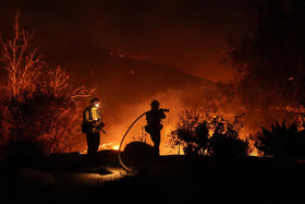
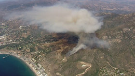
Updated October 15, 2026, 8:45 p.m. Pacific: The Bryson Fire in Malibu grew rapidly Thursday as dry vegetation and strong Santa Ana winds raised the risk of fast-moving flames. NBC Los Angeles reported the fire had reached about 200 acres and remained 0% contained later Thursday evening. Evacuation orders and warnings were in effect in parts of the area. Conditions and boundaries can change quickly, so residents should follow official alerts rather than rely on an article snapshot.
Quick answer: The fire is moving quickly because gusty winds can push flames and carry embers ahead of the main fire, while low humidity and dry brush make vegetation easier to ignite. The National Weather Service has a Red Flag Warning in effect across much of Los Angeles and Ventura counties through Saturday evening. The cause remains under investigation.
What is happening with the Bryson Fire in Malibu?
The fire began Thursday afternoon near Encinal Canyon Road and Mulholland Highway in the Santa Monica Mountains north of Malibu. Rugged terrain and dry brush provide fuel, while wind can push flames through vegetation and scatter embers into unburned areas. News reports later Thursday placed the fire at roughly 200 acres, with containment at 0% at that update. These are time-sensitive figures, not a guarantee of the current perimeter.
Officials issued evacuation orders for some areas and warnings for nearby zones. NBC Los Angeles reported that youth at Campus Vernon Kilpatrick were moved to another facility; no injuries had been reported in its update. Pepperdine University said in a post on X that its Malibu campus was not threatened at the time of its statement and that winds were blowing away from campus. That assessment can change if wind direction or fire behavior changes.
Why a Red Flag Warning makes this fire more dangerous
A Red Flag Warning signals weather conditions that can support critical fire behavior. It does not mean every location will experience a fire, but it warns that any ignition may become difficult to control. The National Weather Service warned of moderate to locally strong Santa Ana winds and low relative humidity, with the warning for much of Los Angeles and Ventura counties extending through 8 p.m. Saturday, October 17.
- Wind: Gusts can push flames toward fresh vegetation and carry embers beyond the fire line.
- Low humidity: Dry air pulls moisture from grass, leaves and brush, making them easier to ignite.
- Continuous fuel: Dry chaparral across hillsides can help flames spread when wind and terrain align.
- Steep terrain: Slopes can complicate access for ground crews and accelerate uphill fire spread.
- Spot fires: Embers landing ahead of the main front can start separate fires and complicate containment.
Evacuation orders and warnings: where to check
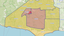
Evacuation zones can change without much notice. Do not use a static screenshot or news story as the final word on whether an address is safe. Check the live official map and follow instructions from law enforcement and fire officials.
Open the live Genasys Protect evacuation map. Also check the Los Angeles County emergency page, the CAL FIRE Bryson Fire incident page, and the National Weather Service Los Angeles/Oxnard.
If you are under an evacuation order, leave promptly using routes recommended by authorities. Do not delay to collect belongings. If you are under a warning, prepare to leave, gather medication and essential documents, charge phones, and plan for pets or anyone who may need extra time. Never drive toward smoke or block emergency access roads.
What residents should do during a Red Flag Warning
- Sign up for official county alerts and check your evacuation zone.
- Keep phones, power banks and essential medical devices charged; power shutoffs may affect communications and traffic signals.
- Avoid activities that can create sparks, including grinding, welding or using equipment in dry brush.
- Keep roads clear for fire engines and follow law enforcement instructions.
- Call 911 if you see a new fire or immediate danger.
Is Pepperdine University threatened?
Pepperdine said in a statement reported Thursday that the fire was about eight miles northwest of its Malibu campus and winds were blowing away from the campus. The university said the campus was not threatened at the time of that post. This is a point-in-time assessment, not a guarantee. Students, employees and visitors should monitor the university's official channels and county alerts for changes.
Pepperdine's statement about the Bryson Fire and the Malibu campus was reported by NBC Los Angeles.
— Source: Pepperdine University on X
Why fire size and containment figures can change
Early acreage estimates come from crews, aircraft, cameras and mapping systems. As teams map the perimeter and identify spot fires, reported size may rise even if flames are not spreading at the same pace at that moment. Containment is different from acreage: a mapped perimeter does not mean control lines are complete. Compare timestamps and use official incident pages for the newest figures.
Frequently asked questions
What caused the Bryson Fire?
The cause was under investigation in the official incident information available Thursday. Do not assume a cause until investigators confirm it.
How large is the Bryson Fire?
NBC Los Angeles reported approximately 200 acres later Thursday evening, with 0% containment at that update. Check the official incident page for the newest figures.
Is there a Red Flag Warning for Malibu?
The National Weather Service issued a warning for much of Los Angeles and Ventura counties through 8 p.m. Saturday, October 17. Check the current forecast for changes.
Where can I find evacuation zones?
Use the Genasys Protect live map and follow county and local fire officials.
Is Pepperdine's Malibu campus in danger?
Pepperdine said it was not threatened at the time of its statement. Conditions can change, so consult the university and emergency officials for current guidance.
Sources and updates
- NBC Los Angeles: Bryson Fire and evacuation updates
- CAL FIRE: Bryson Fire incident information
- Los Angeles County emergency alerts
- National Weather Service Los Angeles/Oxnard
- LAist: Bryson Fire reporting and ALERTCalifornia image
By Shivam Das
This is a developing emergency. Information reflects cited reporting available on October 15, 2026. Follow official instructions and live alerts for safety-critical decisions.