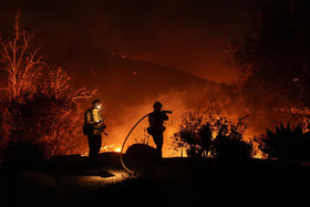
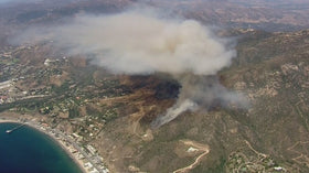
Last updated: October 15, 2026, evening Pacific Time. The Bryson Fire near Encinal Canyon Road in Malibu expanded rapidly on Thursday as strong Santa Ana winds and very dry conditions raised the danger across Southern California. The latest CAL FIRE incident page I reviewed listed the fire at 102 acres and showed evacuation orders and warnings in effect. Conditions and zone boundaries can change quickly, so residents should check official live alerts before making decisions.
Quick answer: The Bryson Fire started near Encinal Canyon Road on October 15. Officials reported a fast increase in acreage, issued evacuation orders for designated zones, and warned nearby communities to be ready to leave. The cause remains under investigation. The immediate priorities are following official evacuation instructions, avoiding closed roads, and monitoring the live incident map.
What is happening with the Bryson Fire in Malibu?
CAL FIRE identifies the incident location as near Encinal Canyon Road in Los Angeles County, with the Los Angeles County Fire Department as the agency in charge. The agency’s incident page recorded growth from 35 acres to 40 acres and then 80 acres during the early updates; a later update listed 101.5 acres, and the current incident page subsequently showed 102 acres. Those figures are snapshots from different update times, not competing estimates of the same moment.
LAist reported that evacuation orders covered zones including KAN-U017 and SYC-U016-A, while nearby zones were under evacuation warnings. Because zone designations can be updated or split into sub-zones, do not rely on a static list in a news story: open the official Genasys evacuation map and confirm the current status for your exact address.
Evacuation orders and warnings: what residents should know
An evacuation order means officials are directing people to leave immediately because of an immediate threat. An evacuation warning means danger may reach the area and residents should prepare to go; people who need extra time, including households with pets, livestock, mobility needs, or medical equipment, should take that warning seriously and leave early if they can do so safely.
Do not drive toward the fire to look at smoke or take photographs. Keep roadways clear for engines and ambulances, follow law-enforcement directions, and do not return to a closed zone until authorities say it is safe. If you see an immediate threat to life, call 911.
Why can the fire spread so quickly?
The main concern is the combination of strong, dry winds and low humidity. Los Angeles County warned before the incident that mountain-area wind gusts could reach 50 to 70 mph during the Red Flag period. Wind can push flames through dry brush, carry embers ahead of the main fire, and create spot fires beyond the visible edge. That means a fire can expand faster than a ground crew can build a containment line, particularly in steep or rugged terrain.
Wind direction matters, too. Pepperdine University said it was monitoring the fire and that winds were blowing southwest and away from its Malibu campus at the time of its statement; the university said the fire did not then pose a threat to that campus. That is a time-specific assessment, not a guarantee about future conditions. Residents should follow their own zone’s alerts rather than infer safety from distance or from a nearby institution’s status.
What is confirmed—and what is not?
- Confirmed: The fire began on October 15 near Encinal Canyon Road in Malibu.
- Confirmed: Official incident updates showed rapid growth, reaching about 102 acres in the latest page reviewed.
- Confirmed: Evacuation orders and warnings were issued for designated zones.
- Cause: Under investigation; no cause should be assumed without an official finding.
- Damage and injuries: Initial reporting listed no confirmed deaths, injuries, or structures destroyed at the time of those reports. These figures may change as officials assess the incident.
Live updates, evacuation map, and official sources
Use these primary sources for changes after publication:
- CAL FIRE Bryson Fire incident page — acreage, status, incident updates, and evacuation information.
- Genasys Protect evacuation map — check the zone associated with your address.
- Pepperdine emergency updates — campus-specific notices.
- Los Angeles County preparedness guidance — Red Flag conditions and safety steps.
- ALERTCalifornia Encinal Canyon camera, Ridgeline camera, and second Encinal Canyon camera — official camera pages; availability may vary.
Official social update
Pepperdine’s public update was reported by CBS Los Angeles. The embedded post below may require X to load and can change or become unavailable.
View the original Pepperdine post on X
Frequently asked questions
Where did the Bryson Fire start?
Officials placed the fire near Encinal Canyon Road in Malibu, in Los Angeles County.
How large is the Bryson Fire?
The latest CAL FIRE incident page reviewed for this article listed 102 acres. Fire acreage can change with new measurements, so check the incident page for the newest figure.
Are evacuation orders in effect?
Yes. CAL FIRE listed evacuation orders and warnings for specific zones. Check the live Genasys map for your address because zone status can change.
What caused the fire?
The cause was listed as under investigation. Strong winds and dry conditions can accelerate spread, but they do not establish how the fire started.
Is Pepperdine University threatened?
Pepperdine said in a statement reported on October 15 that the fire did not then pose a threat to its Malibu campus and that winds were blowing away from campus. Check the university’s emergency page for newer information.
Where can I get reliable updates?
Start with CAL FIRE, the Genasys evacuation map, Los Angeles County public-safety alerts, and relevant local emergency notifications. In an emergency, follow instructions from responders rather than waiting for a news update.
Reporting note: This article is based on official incident information and contemporaneous reporting available at the time of publication. Evacuation details and fire conditions can change rapidly.
Author: Shivam Das